Earth. A seemingly stable, constant fixture beneath our feet. But from its core outward, the planet is anything but constant. It reshapes in response to dramatic events like earthquakes and volcanoes, gradual processes like erosion, and human causes like climatic change. “Geography is only physics slowed down and with a few trees stuck on it,” author Terry Pratchett quipped in Feet of Clay.
Whether we are considering the past, present, or future, scientists are unravelling some of the less than obvious spatial patterns in landscapes and life so we can make better decisions.
Mapping out the pieces of ancient geologies
The town of Snow Lake in Manitoba, Canada, may be far from the ocean, but around 1.8–1.9 billion years ago it was hundreds of meters below the sea surface. Back then, it was also the site of submarine volcanoes that deposited the zinc, copper, and gold that supports a mining industry in the area today. “The more we understand the processes that form these ore deposits, the more likely we are to be able to find new ones,” Vanessa Friesen, an exploration geologist at the mining company Vale, explained.
In their study in the Canadian Journal of Earth Sciences, Friesen and colleagues gathered information from mapping, drill core, and geochemical analysis to reconstruct the volcanic processes that led up to the formation of the ore and its surrounding geology, known as the Powderhouse formation. “Geology is an interesting science because so much of it is creative thought,” Friesen said, who highlights the role of other geologists in laying the groundwork on which her study is based and her collaborators in pulling the pieces of evidence together.
The geology of the Powderhouse formation is complex. Nevertheless, Friesen and her fellow researchers identified 13 distinct lithofacies (formations) and three distinct “mappable members” (unique rock types). Their analysis suggests that two of these were formed by separate volcanoes, each bearing slightly different chemical makeup. Once this period of explosive volcanism ended, the third member developed. During this volcanic hiatus, the ore sought after by mining companies formed.
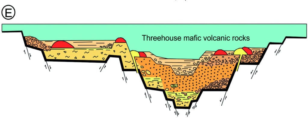
Mafic volcaniclastic rocks of the Threehouse formation. See Figure 12 in Friesen et al.
Friesen’s work can help exploration geologists more precisely pinpoint where ore deposits are most likely hidden beneath the surface. Detailing the genesis of the Powderhouse formation also provides geologists with new leads to figure out what happened in the past to create what we see today; “The present is the key to the past, but it also goes the other way around,” says Friesen.
Mapping the gaps for better forest management
Geological processes of the distant past mould the topography of contemporary landscapes and influence the ecosystems that have developed on them. Soil—a feature that underlies many ecosystems–is created by a mix of organic matter and the underlying and surrounding rocks that are broken down by erosion and weathering. This mix differs over space. So too can the physical and chemical makeup of soil. These differences influence the development of plant species like Balsam fir trees and whole ecosystems like forests.
“Certain soils are more applicable to different types of plant growth, but soil information is often not incorporated in forestry planning,” says Chris Blackford, a Land Resource Specialist at the Ontario Ministry of Agriculture, Food and Rural Affairs. The primary reason why soil information is neglected, Blackford explains, “is that we don’t always have a good understanding of how soils vary across a forested landscape.” In a study published in the Canadian Journal of Forest Research, Blackford and collaborators outline a semi-automated workflow for generating digital soil maps to predict soil attributes across a landscape—including places that haven’t been sampled.
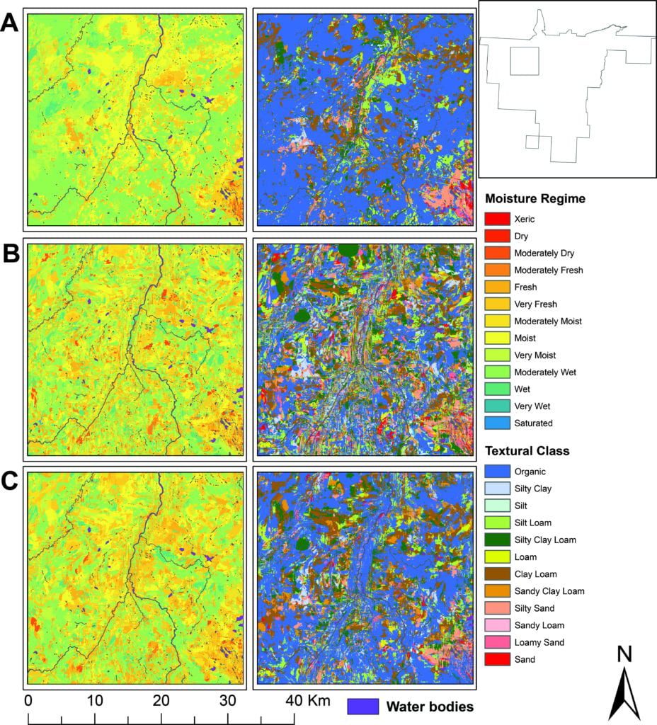
Predicted moisture regime and textural class. See Figure 6 in Blackford et al.
The workflow takes information collected from geo-referenced soil samples (e.g., soil texture) and environmental data (e.g., elevation and slope), as well as features such as lakes and streams, and uses machine learning models to reveal the often complex relationships between soil and its surroundings. “By showing this relationship between soil and environment, and how that relationship can predict soil variation across space, we can improve our management of forests and land use decision making,” says Blackford.
Different species of trees have different affinities to the different soils. From a forestry management perspective, knowing exactly where a particular species could thrive is hugely beneficial. However, generating predictions carries a degree of uncertainty with it. Blackford’s workflow includes using an entropy metric to create maps that show uncertainty in soil predictions across the landscape. No matter how “great” the predictions may be, Blackford notes, areas with high prediction uncertainty should be subject to rigorous, in-situ soil sampling before any management decisions are made.
Mapping the future of Canada’s oceans
Nothing in our world is immutable, something we are struggling to come to grips with in terms of climate change. “Climate change is just a big issue, and it does affect every aspect of ocean life,” Dr. Andrea Bryndum-Buchholz, a post-doc at Dalhousie University explains, highlighting how marine species are already shifting their ranges and changing abundance in response to climate change driven biochemical and physical changes to the ocean. In their work, published in FACETS, Bryndum-Buchholz and colleagues projected what climate change means for Canada’s marine biomass.
The team used an ensemble modelling approach—essentially combining multiple models that project what the ocean is likely to be like in the future under different types of greenhouse gas emission scenarios. “If you just look at one model, it can only include a limited amount of assumptions or processes or dynamics, because that’s how models work—you can’t put everything in. If you combine the models, you get a more complete picture of the ecosystem processes,” Bryndum-Buchholz explains.
Just as in Blackford’s digital soil mapping workflow, Bryndum-Buchholz also captured and mapped uncertainty in the biomass projections. Alongside being important for evaluating projections, the uncertainty also highlights where we are missing vital information—the Arctic. “It’s a very complex ecosystem. The models are not really well developed [for the Arctic] yet, but we could pinpoint where we should focus on developing models in the future,” Bryndum-Buchholz says.
Canada is one of the few countries to have three oceans within its remit—the Arctic, the Atlantic, and the Pacific, each of which are influenced by climate change in slightly different ways. This can translate into differences in biomass changes between the three oceans. “In Atlantic and Pacific, we saw a really strong decrease in marine life biomass, and in the Arctic increases,” Bryndum-Buchholz explains, highlighting the southern portion of the waters in the Atlantic Ocean is projected to see greater declines than the north.
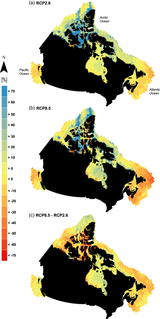
Ensemble biomass projections. See Figure 3 in Bryndum-Buchholz et al.
The magnitude of those biomass changes, however, depended on emission scenario. “Under the lower emission scenarios, the changes were dampened in all areas [compared to high emission scenarios],” Bryndum-Buchholz says. While taking swift, decisive, and meaningful action on our emissions now won’t stop changes from happening, it will make a substantial difference to the intensity of those changes. As Bryndum-Buchholz puts it, “What kind of ocean do we want in the future? I think that’s a good question to ask.”