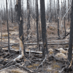
If you open Google Earth and zoom in over the boreal forests of Canada or Finland, you’ll find your screen filled with mottled green. From this satellite view, a forest looks deceptively simple. If you were to analyze the forest from above, you might assign each pixel a numerical value describing how green it is, which would tell you about the amount of healthy, light‑absorbing vegetation in that spot. Looking at the greenness values for all the pixels on your screen, you could begin to infer the overall health and density of that patch of forest. You might start to see some patterns emerging. Going a step further, you could recruit the help of artificial intelligence. AI programs can ingest torrents of this kind of data and spot patterns no human eye could track.
Yet, for researchers like Dr. Jari Vauhkonen, a professor of forest planning and an adjunct professor of forest remote sensing at the University of Eastern Finland, the promises of technological precision belie the stubborn truth that forests are much more complex than satellite imagery alone would lead you to believe. A deep-learning algorithm can parse millions of these values, but it can’t always explain why a stand is shifting or describe what’s going on under that green forest canopy. Forests, of course, are not just a green carpet but a multi-story ecosystem, and that depth can’t be captured through simple modelling. Even the most advanced remote-sensing tools, Vauhkonen notes, must be tested against proven methods grounded in decades of observation and practical use. More data isn’t always better data.
The newest Co-Editor-in-Chief of the Canadian Journal of Forest Research, Vauhkonen has built his career at the intersection of sillviculture and technology, where decisions must be made even when the data isn’t perfect. In this conversation, we explore the possibilities and limitations of AI, the value of honest critique, and the need for reliable measurements, especially as forests shift on a warming planet.