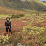
Ten kilometres south of Tuktoyaktuk, Northwest Territories, a small drone rises into the air. Over the next 15 minutes, it will photograph the same few hectares of tundra more than 600 times. Later, these images will be downloaded to a computer and digitally stitched together to create a high-resolution, three-dimensional representation of the area. The map will reveal new details in a story that is already familiar to many: the Arctic isn’t what it used to be.
“Over the past few decades, the Arctic has been warming at double the rate of the rest of the world,” says Robert Fraser, a research scientist with the Canada Centre for Mapping and Earth Observation. Fraser specializes in remote sensing, including satellite images. He used to study forest fires, but for the last decade he has focused on tracking the rapid changes taking place across Canada’s northern regions.
According to Fraser, one of the most widespread effects on land has been an explosion in the populations of Arctic shrubs, such as willows, birches and alders. “The warming of the ground and the increased depth of the thawed soil has allowed them to expand out from their current areas,” says Fraser.
The new shrubs aren’t necessarily a welcome addition. Their cast-off leaves can smother reindeer lichens, currently a common form of ground cover on the tundra. Barren-ground caribou depend on the lichens as a source of high-energy food, so habitat changes caused by more shrubs—combined with a host of other pressures—could mean fewer caribou, and less meat for the animals and people who hunt them.
Moreover, shrubs form a much darker surface than bare tundra, and therefore reflect less of the sunlight they receive back into space. By trapping heat closer to the surface, the new shrubs could further speed Arctic warming, which in turn would enable further shrub expansion and create a positive feedback effect.
Until now there have been two main methods for tracking changes in Arctic vegetation. The first is satellite imaging, which is very effective at covering vast areas. Unfortunately, the level of detail—what Fraser calls spatial resolution—is low. “The satellites we use have a resolution of 30 metres,” says Fraser. A plot of land the size of a football field would appear as only a few pixels; too small to see subtle changes in vegetation.
For this reason, satellite images always have to be “ground truthed” with manual surveys. For the last several years, Fraser and his team have collaborated with Professor Trevor Lantz at the University of Victoria to monitor a series of test plots near Tuktoyaktuk. Graduate students and other researchers hike across the area, counting the shrubs by hand. “It’s very accurate, but it’s also very labour-intensive and each plot measurement usually only covers one square metre,” says Fraser.
Fraser hopes that drones could bridge the gap between manual surveys and satellite data. His aerial surveys involve taking multiple photos of the same object from different angles. Computer algorithms then resolve these separate shots into a cohesive, three-dimensional map. The technique, known as structure from motion (SfM), is similar to the way that our brains estimate the distance to an object by comparing information from our right and left eyes.
A big question for Fraser and his team was whether drone photography would be sensitive enough to pick up year-on-year changes in the height of vegetation. To find out, the team flew surveys both before and after trimming the shrubs in several areas. Sure enough, the maps were noticeably different. Their latest paper, published in Arctic Science, concludes that drones provide a “promising, cost-efficient method for high-resolution mapping and monitoring of tundra vegetation.”
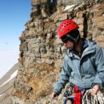
This summer, Fraser and his colleagues travelled to the new Canadian High Arctic Research Station in Cambridge Bay, Nunavut, to test their drone surveys in an even more northerly environment. They are also working with the government of the Northwest Territories and University of Ottawa to monitor the growth of thaw slumps, another symptom of climate change. “My belief is that within a few years drones will be a common part of the tool kit for Arctic researchers,” says Fraser. “The more we know about what changes are happening, the better we will be able to adapt.”
To learn about the latest in drone technology and the applications of unmanned systems to studying the environment, check out the Journal of Unmanned Vehicle Systems.