Aniruddho Chokroborty-Hoque

Research communicator who has happily migrated from a fifteen-year stint conducting research to a lifetime of writing its stories.

Artificial intelligence takes to the sky above Canada’s forests

March 29, 2021 | 4 minute read

Canada’s forests are scattered in research labs across the nation.

In one laboratory, forest fires weave their way through computer code, ending up on screens in pixels and probabilities.

In another, algorithms are learning to “see” conifers in ones and zeroes.

Both laboratories are leveraging artificial intelligence (AI) to understand and protect Canada’s forests.

In a study published in the Journal of Unmanned Vehicle Systems, York University PhD student Sowmya Natesan and colleagues outline their development of an AI algorithm that accurately identifies conifer species from images of trees.

Construction and paper industries around the world use conifer wood. Canadian pines, firs, spruce, and cedars are big exports, critically important to the country’s economy.

A key way to ensure that Canada’s forests remain productive is to “understand the presence and status of trees” according to Udayalakshmi Vepakomma, lead scientist at FPInnovations and co-author of the article.

Improved knowledge of tree species means that the forest industry can better manage and use these natural resources.

Foresters fly unmanned aerial vehicles (UAVs) with cameras attached, taking pictures of tree canopies. They use image processing software to try and identify the trees, but often fail.

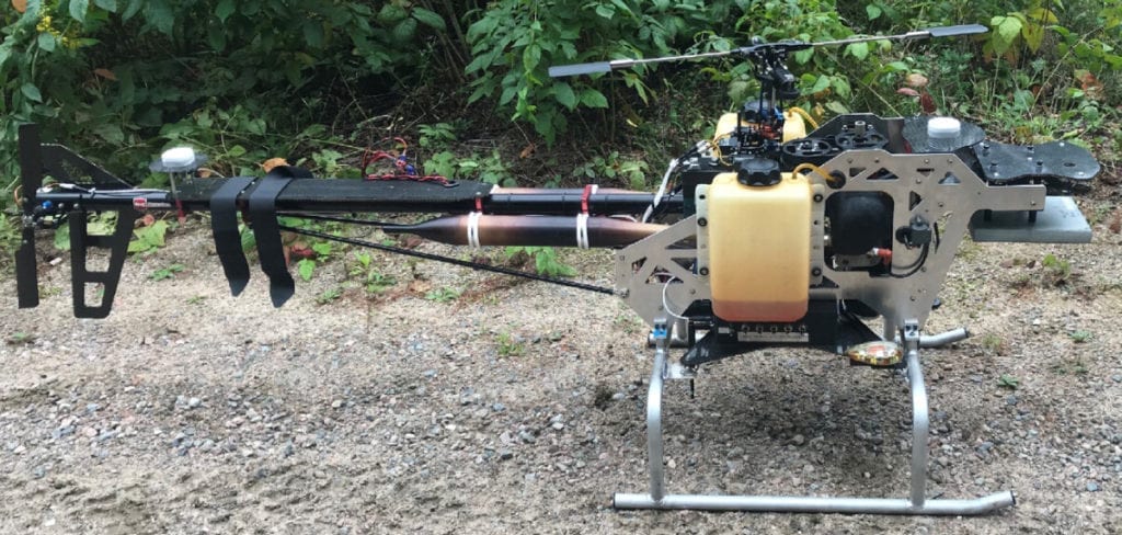
Unmanned aerial vehicle platform | Natesan et al.

Current software requires high-quality pictures, but the quality of pictures captured by UAVs often varies. It depends on factors like camera angle, season, and lighting conditions.

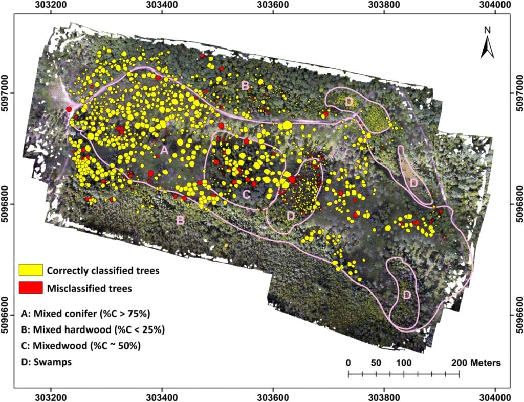
The team studied forest canopies of Ontario’s Petawawa Research Forest. They collected hundreds of images over three years in different seasons, times of day, sunlight amount, and camera angles. These initial images were used to “train” the software so it could learn to correctly identify tree species.

More training data means more information for the software to learn from and develop faster pattern recognition and more accurate identification.

When put to the test, the AI software encountered previously unseen images of trees. It “sieved” them through various computational layers, each identifying features such as leaf outline and branch shape, curves, and colour. The software referred to its training data and then, with a degree of certainty, determined the number of trees in each image that are conifers.

The program is a good learner—when asked to decipher new tree images of varying quality, it identified conifer species with 84% accuracy.

Map of correctly classified and misclassified trees in different stand conditions | Natesan et al.

“The importance of our work does not lay with data collection and images,” says York University geomatics engineering professor Costas Armenakis and principal investigator of the study. “Data processing is the heart of the system—this is what will lead to species identification.”

Smart AI flying in UAVs above Canadian forests are also lending a helping hand in combating forest fires, the frequency of which are expected to increase in North America over the next century because of climatic change.

A forest fire, in its early stages, may not even have a flame or it could be hidden beneath the forest canopy. But smoke appears earlier than flame and can be detected from far away. At night, however, smoke becomes invisible.

PhD student F.M. Anim Hossain and colleagues at Concordia University’s Department of Mechanical, Industrial, and Aerospace Engineering have developed an AI-based fire detection method that identifies both flame and smoke from aerial images taken by UAVs.

“You are trying to decrease detection time and increase efficiency with which fire fighters can combat fires as early as possible,” says professor Youmin M. Zhang and principal investigator of the study published in the Journal of Unmanned Vehicle Systems.

Recent fires in Australia, North America, Southern Europe, and Southeast Asia—millions of hectares burnt—give us a glimpse of the future: countless individuals evacuated, left homeless, or their lives taken.

The researchers gathered aerial forest fire images and videos from all over the world, including recent wildfires of California and Australia and those in the Canadian provinces of British Columbia and Alberta.

Much like Natesan and colleagues’ work, hundreds of images were used to train the software, and hundreds of images were used to test it.

The AI principle is also similar—evaluate each image for colour, shape, texture, or motion, for example, and then assign a probability to the final evaluation of smoke or fire. The software is highly precise in detecting both.

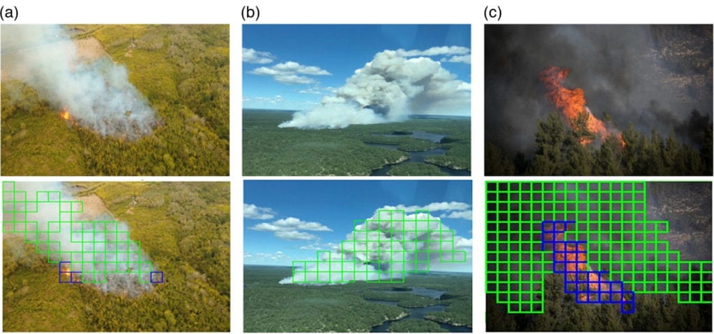
Aerial forest fire images (top row) and successful detection of smoke and flame (bottom row) | Adapted from Hossain et al.

Importantly, the AI does not require much computational power and processes results in real-time. Onboard a UAV, this is important. It frees the UAV’s computer to do other tasks such as maintain flight control, navigate around fires, and communicate quickly to fire teams about imminent dangers.

Forest fires can quickly change from small sparks into out-of-control blazes. The ability for AI to quickly assess and evaluate its environment and relay its decision to fire authorities will be critical.

“We want to equip UAVs with autonomous decision-making capabilities, and automatically warn fire authorities even before fires have started,” Youmin says.

Aniruddho Chokroborty-Hoque

Research communicator who has happily migrated from a fifteen-year stint conducting research to a lifetime of writing its stories.